A step-by-step guide to the 1,717-metre summit — tour options, trail conditions, summit experience, and everything in between.
The alarm sounds at 2 a.m. It is not a gentle sound. The room is dark, the air outside your villa is cool and still, and for a moment — the moment every Batur hiker knows — you question the decision you made with such enthusiasm the evening before. Then you remember why you booked it. You get up.
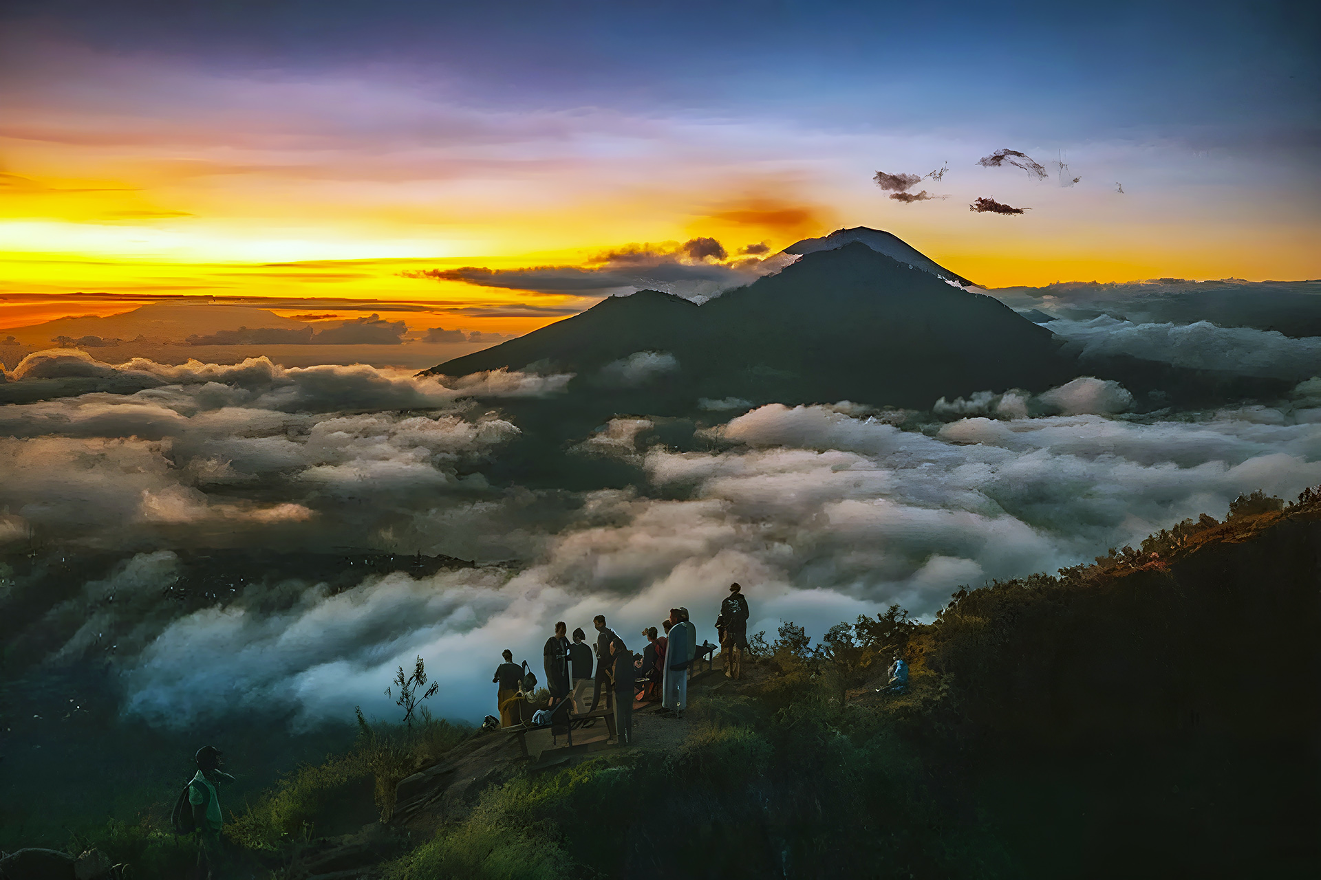
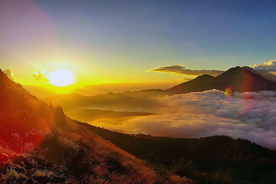
By the time you reach the trailhead at Toya Bungkah, the stars are thick above the caldera and the volcano’s black silhouette rises against them like a cut-out. Other hikers move through the darkness with torches. Your guide knows every stone. And roughly two and a half hours later, you are standing on the rim of an active volcano, watching the sun pull itself out of the Lombok Sea and flood the island of Bali — all of it, from Agung to the sea — in amber and rose and gold.
Mount Batur is not Bali’s tallest peak, nor its most dramatic in photographs. What it is, consistently and reliably, is the island’s most transformative morning. This guide covers everything from booking a tour to descending safely — so the only thing you have to think about on the mountain is the view.


💡Related reads:
What Is Mount Batur?
Gunung Batur is an active stratovolcano rising to 1,717 metres above sea level in the Kintamani highlands of Bangli Regency, roughly 65 kilometres north of Kuta. It sits inside a vast ancient caldera — itself the remnant of a far larger prehistoric volcano — and shares the landscape with Batur Lake (Danau Batur), the largest crater lake in Bali, which fills the western half of the caldera floor below.
The volcano has erupted more than 20 times since records began, most recently in 2000. Its last significant eruption was in 1994. The volcanic activity today is mild: steam vents near the summit crater emit sulphurous gas, and on clear mornings you can watch wisps of white smoke rise from the rocky ground as though the mountain is still deciding whether to wake up. For hikers, these vents are part of the experience — a reminder that you are walking on something genuinely alive.
The Batur caldera is a UNESCO-listed Global Geopark, recognised for its geological significance and the cultural landscape it contains. The nearby village of Trunyan, famous for its open-air Bali Aga burial ground, sits on the eastern shore of the lake below. The entire area carries weight — geological, spiritual, and historical — that the sunrise, beautiful as it is, only underlines.
Location & How to Get There
Where Is the Trailhead?
The most common starting point for the Mount Batur sunrise hike is the village of Toya Bungkah, on the southwestern shore of Batur Lake at the base of the volcano. Most organised tours begin here. The GPS coordinates for the main car park and trail registration area are approximately –8.2421, 115.3897.
The road up from Ubud through Kintamani is well-paved but steep in sections, with some sharp bends. From the south, the drive through Penelokan — the rim village with its famous caldera panorama — is part of the experience. Most pickup vehicles depart south Bali between midnight and 1:30 a.m. to reach the trailhead by 3:30–4 a.m., giving hikers time to ascend before first light.
DEPARTURE POINT |
DISTANCE TO TOY BUNGKAH |
APPROX. DRIVE TIME |
|---|---|---|
Ubud
|
38 km
|
1 hr 15 min
|
Kuta / Seminyak
|
80 km
|
2 hr – 2 hr 30 min
|
Canggu
|
85 km
|
2 hr 15 min – 2 hr 45 min
|
Sanur
|
72 km
|
2 hr
|
Nusa Dua
|
88 km
|
2 hr 30 min
|
Lovina
|
52 km
|
1 hr 30 min
|
Getting There
There is no public transport that serves Toya Bungkah in time for a sunrise hike. Your realistic options are:
Private driver (self-arranged): If you have a trusted driver or rent a scooter from the south, you can reach the trailhead independently. Expect to pay IDR 350,000–600,000 for a return charter from Ubud, more from the south. You will still need to arrange a guide on arrival — hiking unguided is officially prohibited and practically inadvisable in the dark.
Organised tour package: The simplest option for most visitors. A guide, transport from your accommodation, and a summit breakfast are included in a single price. See the Tour Options section below for what to expect.
 Insider's Tips — Getting to the Trailhead
 Insider's Tips — Getting to the Trailhead
- Confirm your pickup time the evening before. Most guides send a WhatsApp reminder — if they don’t, send one yourself.
- Dress at the accommodation, not at the car. Getting into hiking clothes in a dark vehicle at 2 a.m. is unpleasant.
Arrive ready.
- The drive is part of the experience. Kintamani highlands at 3 a.m. are quiet. Stay awake for the caldera descent — the view even at night is something.
- Petrol stations thin out above Ubud. If driving yourself, fill up before you leave — highland stations open late and close early.
Tour Options & Costs
Almost every visitor joins an organised tour, and the market for Batur hikes is enormous — with pricing to match every budget and quality expectation. Understanding what you are actually buying matters.
Standard Group Tours
Budget operators charge between USD 25–40 per person for a group sunrise hike. These packages typically include transport from Ubud (add USD 5–10 from south Bali), a licensed guide, and the summit “breakfast” — a hard-boiled egg steamed in volcanic vents and a banana, usually with instant coffee or tea. Groups can be large: 8–15 people is common, sometimes more.
This is perfectly adequate for fit, independent travellers who are comfortable navigating a crowd on the trail and at the summit. The views are identical regardless of what you paid. What differs is pace, flexibility, and the quality of information your guide shares during the climb.
Private Tours
A private guided hike — your own vehicle, your own guide, your own pace — typically costs USD 60–100 per person depending on the operator, group size, and departure point. The additional cost buys you real flexibility: you stop where you want, you summit when you want, and your guide’s attention is entirely on you. If you want to spend 45 minutes on the summit photographing the light before descending, no one is waiting.
Premium Experience Packages
We have curated packages that combine the Batur hike with a caldera breakfast at a proper café overlooking the lake, hot spring access after descent, and occasionally a cultural stop at a Kintamani village or temple on the return. For USD 120–180 per person it represent a genuinely different kind of day: one that begins at the summit and unfolds slowly through the morning rather than rushing back to the hotel by 9 a.m.
PACKAGE TYPE |
PRICE RANGE (PER PERSON) |
BEST FOR |
|---|---|---|
Budget group tour
|
USD 25–40
|
Solo travellers, flexible pace, tight budget.
|
Private guided hike
|
USD 60–100
|
Couples, families, photographers.
|
Premium full-day package
|
USD 120–180
|
Relaxed explorers wanting more than the summit.
|
One caveat worth stating directly: guide quality varies enormously. The licensing system in the Batur area is controlled by the PHRI Batur Association, which means all guides operating here are officially registered — but registration does not guarantee English fluency, geological knowledge, or any particular effort to make your experience memorable. Ask your operator who the guide is, how long they have been doing the hike, and whether they speak English comfortably.
A great guide on Batur — one who points out the active vents, explains the eruption history, and knows when to stop and let the silence do its work — is worth paying for.
A great guide on Batur knows when to stop talking. The summit at dawn is not a classroom. It is a place you need a few minutes of silence to actually absorb.
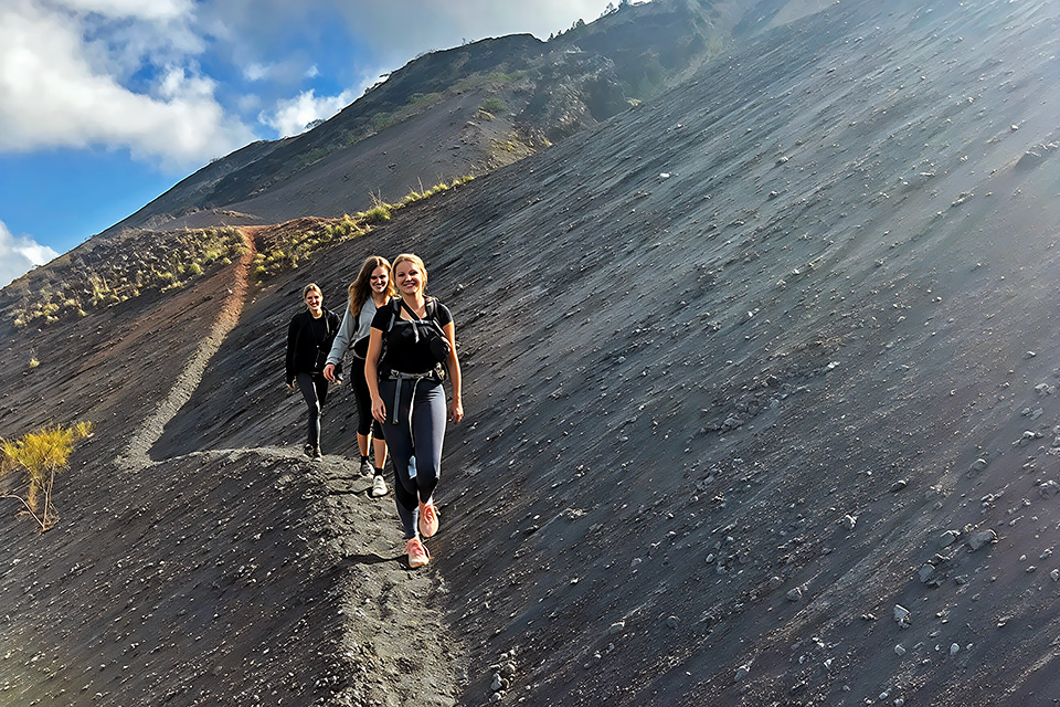
The Trail: What the Climb Actually Looks Like
The standard Toya Bungkah trail gains roughly 700 metres of elevation over a distance of approximately 6 kilometres to the summit. The hike up typically takes 2 to 2.5 hours at a moderate pace. The descent is faster — 1.5 to 2 hours — though the loose volcanic gravel on certain sections requires more care going down than up.
The Ascent
The first section from Toya Bungkah is a gentle warm-up: a flat path through the caldera floor in total darkness, picking through sparse vegetation. The trail narrows as the gradient increases. Within 30 minutes, you are properly climbing.
The middle section is the honest work. The trail here is a mix of hardened lava rock and loose volcanic scree — dark grey and rust-coloured, catching your torchlight in odd ways. There are no steps, no handrails, and very few flat sections. You are simply moving upward, and the rhythm of it — the steady breath, the careful footing, the cone of light from your head torch — becomes meditative in a way that surprises most first-timers.
At around the 1,550-metre mark, the trail flattens briefly into a false summit that has caught out many exhausted hikers into premature celebration. The actual summit is another 20–25 minutes beyond. Keep going.
The Summit
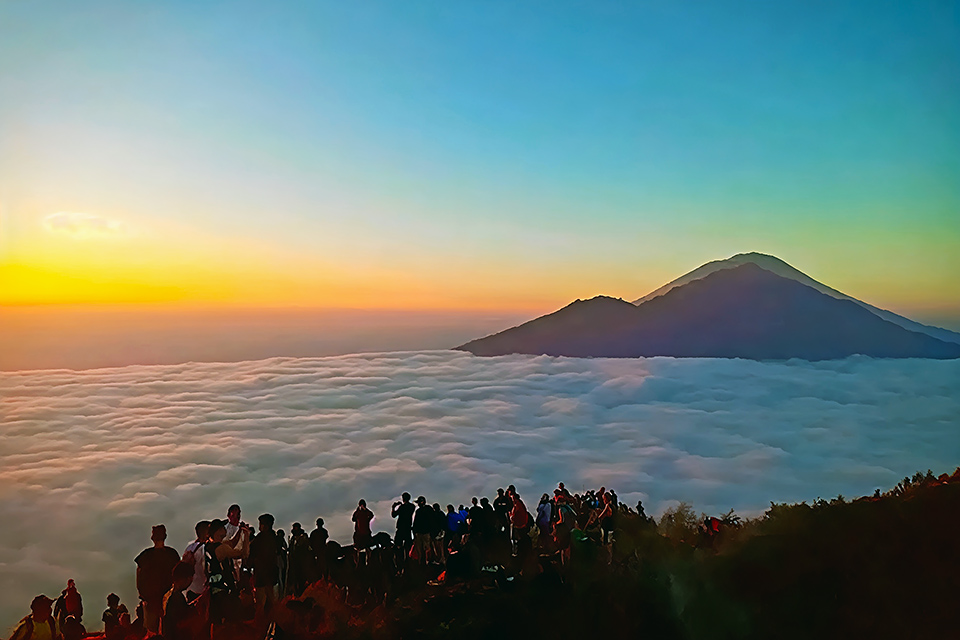
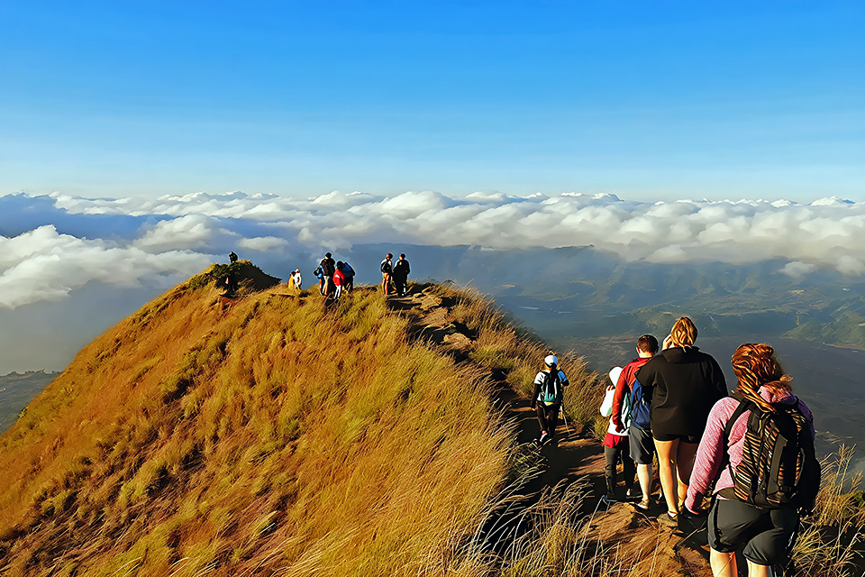
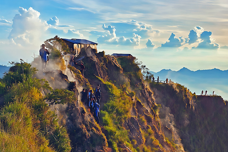
The rim of Mount Batur is roughly circular and about 300 metres across at its widest. Several craters exist at the summit — Batur I, II, and III — and the main viewpoint sits above the largest. Steam vents near Batur I emit a faint sulphurous odour that you notice more on some days than others depending on wind direction. Stand upwind.
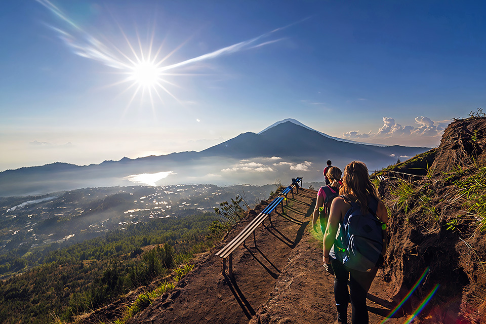
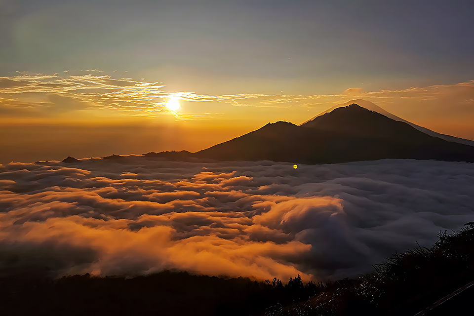
On a clear day — which happens on the majority of dry-season mornings — the summit view takes in Mount Agung to the southeast (3,031 metres, Bali’s highest and most sacred volcano), the caldera and Batur Lake far below, the northern coast of Bali, and on exceptional mornings, the islands of Lombok, Nusa Penida, and even the faint outline of Java to the west.
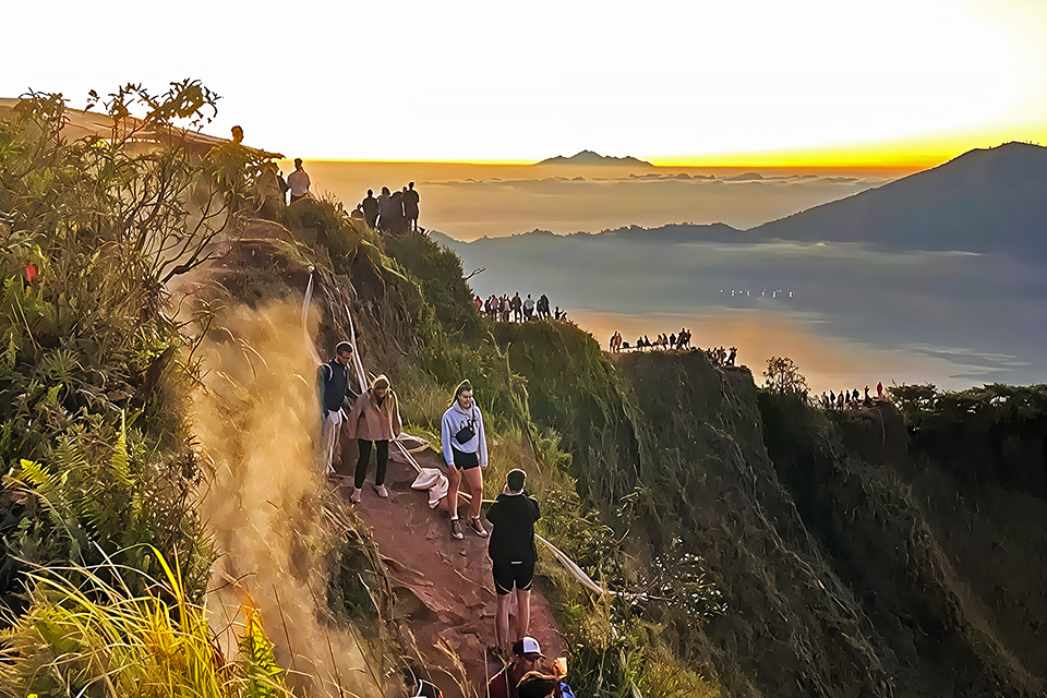
The sunrise itself rarely disappoints. First light appears as a faint brightening on the eastern horizon sometime between 5:30 and 6:15 a.m. depending on the season. The light shifts quickly — pastel pinks deepen to orange and then to the full white glare of a tropical morning — and the mountain goes from cold and quiet to busy and warm within the space of about 45 minutes. Most people begin their descent by 7 a.m.
The summit is not the end of the hike. It is the beginning of the morning. The hikers who descend immediately after sunrise are the ones who miss the hour that makes the whole climb worthwhile.
The Descent
The loose volcanic gravel that felt solid underfoot on the way up becomes more treacherous on the descent, particularly in the middle section where the gradient steepens. Take your time. Trekking poles are genuinely useful here — not because the trail is dangerous, but because an hour of downhill on volcanic scree in worn trail runners concentrates a surprising amount of stress on the knees and ankles.
Most groups are back at Toya Bungkah by 8–9 a.m. From there, the conventional programme is breakfast at a lakeside warung before the return drive. If you have booked a premium package, the hot springs at Toya Devasya — a 10-minute walk along the lake shore — are a logical and deeply satisfying way to spend the post-hike hour.
Difficulty, Fitness & Who This Trek Is For
Mount Batur is consistently classified as a moderate hike — which in practice means it is accessible to most reasonably fit adults who walk regularly, but it is not a stroll. The challenge is less about technical difficulty and more about the cumulative effort of sustained uphill movement in the dark, often after a short or disrupted night’s sleep.
People of a wide age range complete this hike successfully every morning: families with children over ten, travellers in their sixties, people who describe themselves as not particularly sporty. The limiting factors are usually cardiovascular fitness and footwear, not experience or age.
FACTOR |
BEGINNER |
MODERATE FITNESS |
REGULAR HIKER |
|---|---|---|---|
Summit time
|
2.5–3 hrs
|
2–2.5 hrs
|
1.5–2 hrs
|
Difficulty level
|
Hard
|
Moderate
|
Easy–moderate
|
Knee stress on descent
|
Significant
|
Moderate
|
Low
|
Recommended poles
|
Yes
|
Recommended
|
Optional
|
That said, certain conditions genuinely affect the experience. If you have a significant knee or ankle injury, the descent on loose scree can aggravate it. If you are visiting during the wet season (November–March), rain makes the trail slippery and cloud often obscures the view entirely — which eliminates the point of the early start. And if you have never done any uphill hiking before and your daily activity is limited, the middle section will feel harder than you expect. Allow for that.
Best Time to Visit
Time of Year
The dry season — May through October — is the undisputed best period for the Batur sunrise hike. Clear skies are the rule rather than the exception, and the summit view in June or July is as good as it gets: sharp, wide, and colourful in ways that photographs struggle to capture. July and August bring peak crowds to the trail, but the mountain is large enough to absorb them.
The shoulder months of April and November offer something close to dry-season conditions with meaningfully fewer hikers. These are arguably the best months of all if your timing is flexible.
November through March brings the wet season, and with it, a significant deterioration in summit visibility. Cloud rolls in off the coast overnight and frequently sits on the caldera through sunrise and well into the morning. You can hike in the wet season — the trail is not impassable — but the chance of arriving at the summit to find yourself inside a cloud is genuinely high. Check forecasts obsessively if you are visiting in this period, and be prepared to reschedule.
Day of the Week
Weekends, particularly Saturday nights, bring Indonesian domestic tourists to Batur in significant numbers. For a quieter trail experience, Sunday through Thursday mornings are noticeably less crowded. This matters most at the summit, where popular photography spots can have queues of 15–20 people on busy mornings.
Moon Phase
A full moon on Batur is a memorable thing: the caldera below reflects the moonlight off the lake surface, and the ascent can be completed with minimal torch use. If your trip dates are flexible and the dry season moon aligns with a clear night, adjust your schedule accordingly.
Insider's Insight — Reading the Weather
- Check at 10 p.m., not at 6 p.m. Evening cloud conditions in the highlands shift significantly in the late evening. A murky sunset at Kintamani does not predict a cloudy summit.
- Windy is good. Surface wind in the caldera typically means the cloud layer is moving — which usually means a cleaner view at dawn.
- Ask your guide directly. Experienced Batur guides check conditions nightly. A good one will tell you honestly if it looks unpromising.
- The wet season cut-off is not absolute. Some of the most dramatic Batur sunrises happen in October and April — storms to the east, golden light to the west, layers of cloud below the summit. It just requires luck.
What to Wear & Bring
Packing for the Batur hike is a balance between the cold of the pre-dawn caldera — temperatures at the summit can drop to 10–13°C before sunrise — and the heat of the descent, which in the dry season can be genuinely warm by 8 a.m. The classic mistake is underpacking for the cold and overpacking for the heat.
Clothing
- Base layer (moisture-wicking, not cotton) — critical.
- Mid layer: a light fleece or windproof jacket for the summit.
- Outer layer: a waterproof shell (wet season) or light wind layer (dry season).
- Long pants or convertible trousers — the summit. wind cuts through shorts
- Gloves: lightweight, packable — genuinely useful in dry-season June and July.
- Hat or beanie for the summit.
Footwear
Trail runners or light hiking boots with ankle support and a proper grip sole. Flip-flops and running trainers are both technically permitted and actively inadvisable — the volcanic scree on the descent has sent more than a few over-confident hikers sliding. If you only own smooth-soled shoes, ask your tour operator about rental options in Toya Bungkah.
Pack Essentials
- Head torch — essential; your phone torch is not enough for 2+ hours of dark trail.
- Water — minimum 1.5 litres per person.
- Snacks — the volcanic breakfast is small; bring something real.
- Small cash — for tips, post-hike breakfast, and the hot springs.
- Trekking poles — light and foldable poles pack small and make a genuine difference on the descent.
- Sunscreen — you will be at the summit as the UV intensity ramps up fast.
- Camera + spare battery — cold temperatures drain batteries faster than you expect.
Insider's Tips — What to Leave Behind
- Large backpacks. A 10–15 litre daypack is plenty. You are not camping.
- Heavy DSLR rigs. Unless you are shooting professionally, a mirrorless or compact camera is more than enough — and far less punishing on the climb.
- New shoes. The worst possible time to discover a hot spot. Break them in first.
- Too many layers. You will overheat on the ascent and carry the excess. One good wind layer at the summit is better than three that you tie around your waist.
Photography Guide
Mount Batur produces two genuinely different photographic experiences, and they require different preparation. The pre-sunrise period — from arrival at the summit until the disc clears the horizon — rewards patience and stillness. The post-sunrise hour, as light floods the caldera, rewards movement.
Pre-Dawn Preparation
Set up before you need to. Find your position on the eastern rim at least 20 minutes before civil twilight begins. The best viewpoints on busy mornings fill up quickly — a wide-angle lens on the caldera side and the Agung silhouette to the southeast are both worth staking out early.
For phone photographers: the computational night mode on modern iPhones and Android flagships handles the pre-dawn scene surprisingly well. Brace the phone against your knee or a rock, use the timer, and let the software work. Manual exposures in true darkness are hard to get right without practice.
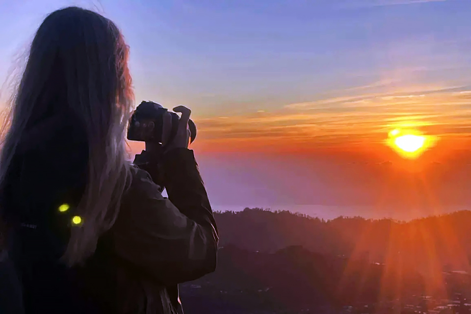
The Golden Window
The eight to twelve minutes immediately around sunrise — from the first orange lip of the sun clearing the horizon to the moment the disc becomes too bright to shoot directly — is the window. Bracket your exposures. Shoot toward the light and away from it. The lake surface in the caldera below often catches the first light beautifully; turn around at least once during the sunrise itself.
The Overlooked Shot
Nearly every Batur photograph shows the sunrise to the east. Almost none show what is happening to the west — the shadow of the volcano itself, projected across the caldera and the distant sea as a vast triangular darkness retreating with the dawn. It lasts perhaps 15 minutes. Turn around.
After the Hike: What to Do Next
The most common post-Batur experience is a quick breakfast and a long drive home. It is also a waste of one of the most atmospheric landscapes in Bali. The caldera is remarkable in morning light, and spending another two or three hours there — rather than rushing south — transforms the hike from a bucket-list tick into something more like a day.
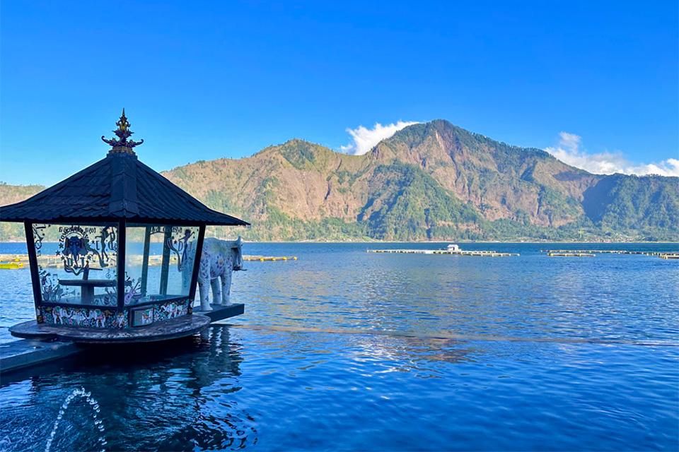
Hot Springs at Toya Devasya
The natural hot springs on the shore of Batur Lake — fed by geothermal activity from the volcano — are one of Bali’s genuinely restorative experiences. The main facility at Toya Devasya offers tiered pools at various temperatures overlooking the lake, with the caldera rim and the volcano visible in the background. Entry costs around IDR 150,000–200,000. After two and a half hours of uphill hiking, lowering yourself into 38°C water beside a volcano while the morning mist lifts off the lake is not something you will regret.
Breakfast at the Caldera Rim
If your tour includes a return through Penelokan — the village on the caldera rim with its long row of restaurants overlooking the valley — stop for a proper Balinese breakfast. The view from those terraced warungs across the entire caldera at 8 a.m., with Batur steaming quietly in the middle distance, is exceptional. Give it time. Order more coffee than you need.
Pura Ulun Danu Batur
The main temple of the caldera — one of Bali’s nine directional temples, or kahyangan jagat — sits in Kintamani village at the rim, rebuilt at its current location after the 1926 eruption buried its predecessor. It is open to respectful visitors and is far less crowded in the morning than during the afternoon tour-bus peak. Worth 45 minutes on your return if you have not visited before.
Safety & Responsible Travel
Mount Batur has an excellent safety record as active volcano hikes go. The trail is well-worn and the guide system provides a meaningful level of oversight. That said, a few specific risks deserve direct mention.
The summit vents: The active fumaroles near Batur I emit sulphur dioxide, which in high concentrations causes respiratory irritation. Healthy adults are at minimal risk during a brief visit, but anyone with asthma or respiratory conditions should stay upwind of the vents and avoid lingering near them. If the smell is strong on the day you visit, take that seriously.
Night trail navigation: The trail is not technical, but it is steep in sections and a serious fall in the dark is possible. Never leave your guide’s group to explore side paths alone. Torches with fresh batteries, not dying phone screens.
Altitude and dehydration: At 1,717 metres, altitude sickness is not a significant concern for most people — the elevation is too low for the condition to present. But the combination of a short night, sustained physical effort, and insufficient water can produce symptoms that look similar. Drink consistently throughout the climb. Start before you feel thirsty.
Rubbish: The Batur trail accumulates significant litter despite ongoing clean-up efforts, most of it from the summit breakfast. Carry out what you carry up. The volcanic egg wrapper, the banana peel, the instant coffee sachet — they go in your pack.
Plan Your Visit NOW!
There is a specific quality of clarity that comes from standing on a summit at dawn — something about the combination of effort earned and light arriving — that is hard to produce any other way. Batur delivers it reliably. The trail is honest, the guide system works, the sunrise is the sunrise. It asks two and a half hours of walking in the dark and returns something considerably larger.
The hikers who leave with the best memories are the ones who stay a little longer at the top. Who eat the volcanic egg slowly. Who turn around to watch the mountain’s shadow retreating across the lake. Who skip the rush back to the hotel for the hot springs and the long breakfast on the caldera rim instead. The mountain is not going anywhere. Give the morning room to unfold.
By the time you are back at the trailhead, the sun is already high and warm and the rest of Bali is just waking up. You will have already lived a whole day before breakfast.
💡Related reads:
FAQ
Do I need a guide to hike Mount Batur?
Yes. The local guide association controls access to the trail and unguided hikers are stopped at the checkpoint. Beyond the regulation, hiking in total darkness on an active volcano without local knowledge is genuinely inadvisable. Hire a guide — it is not a meaningful additional cost and it significantly improves the experience.
What time does the hike start, and when do we reach the summit?
Most tours begin the ascent between 3:30 and 4:00 a.m. to reach the summit approximately 2 to 2.5 hours later, timed to arrive before civil twilight. The sunrise itself varies by season: roughly 5:45 a.m. in June–July, closer to 6:15 a.m. in December–January. Your guide will calibrate the pace accordingly.
Is Mount Batur safe for children?
Many families complete this hike with children aged 10 and above without difficulty. Younger children should be assessed based on their individual fitness and night-time hiking comfort. The main concern is the pre-dawn start and the loose descent — not the gradient itself, which is steep but not technical. Bring head torches for all participants and keep young children between two adults on the trail.
Can I hike in the wet season?
You can. But cloud cover frequently sits on the summit through sunrise in the wet months (November–March), meaning you may complete the entire hike and see nothing from the top. Check forecasts carefully, confirm with your guide the evening before, and consider a refund or rescheduling policy if you are travelling in this period.
What is the volcanic egg breakfast?
A Batur tradition: hard-boiled eggs steamed directly in the active vents near the summit crater, served with a banana and instant coffee or tea. It is simple to the point of austerity, and for that reason it is one of the more memorable meals you will eat in Bali. The novelty of cooking breakfast on a live volcano does not diminish on arrival.
Are trekking poles available to rent?
Some operators and guesthouses in Toya Bungkah rent basic trekking poles for IDR 30,000–50,000 per pair. Confirm availability when booking if you plan to use them. Lightweight foldable poles — the kind that fit in a cabin bag — are worth bringing from home if you do significant hiking generally.
What happens if it rains at the summit?
A waterproof shell and reasonable footwear make a rainy Batur summit manageable, but the view and the experience are significantly diminished. Reputable operators offer a reschedule for weather-caused cancellations — confirm this policy before booking.
Is there a toilet on the trail?
A basic toilet facility exists at the trailhead in Toya Bungkah. There are no facilities on the trail itself. Plan accordingly before departure.
How does Mount Batur compare to Mount Agung?
Both are active volcanoes and both offer extraordinary sunrise views. Batur is the accessible option: the hike is shorter, the trailhead is lower, the difficulty is moderate. Agung — at 3,031 metres — is a serious undertaking requiring 5–6 hours of ascent, cold temperatures, and meaningful fitness. Batur is for most visitors; Agung is for experienced trekkers who want to earn something harder.
Can I hike both Batur and Agung in one Bali trip?
Yes, if you have the fitness and the schedule. Most visitors complete Batur early in their trip, assess how they felt on it, and then decide whether Agung warrants the additional commitment. The two hikes require a minimum of two separate nights given the pre-dawn starts, so allow at least four or five days in the highlands if both are on your list.
Last updated June 2026. Prices, fees, and trail conditions are subject to change. Always confirm current details with your tour operator prior to your hike. HalloBALI offers private and group Batur sunrise tours departing from all major Bali locations — contact us to arrange your climb.